Amazing Place (Natural Bridge)
Natural Bridge in Virginia
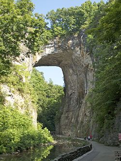
Has been called from its natural name, which means natural or formed by nature itself.Natural Bridge is a geological formation in Rockbridge County, Virginia, comprising a 215-foot-high (66 m) natural arch with a span of 90 feet (27 m).It is situated within a gorge carved from the surrounding mountainous limestone terrain by Cedar Creek, a small tributary of the James River.Natural Bridge is the remains of the roof of a cave or tunnel through which the Cedar Creek once flowed.
Natural bridge has been designated a virginia Historic Landmark,Since 2016,the bridge and its surroundings have been managed by the Commonwealth of Virginia as Natural Bridge State Park.
The Natural Bridge was the remnant of an underground river tunnel that diverted water to the south . Initially, the underground river starts capturing water from the Poague Run about two miles (3.2 km) to the north, contributing to enlarge the incipient Cedar Creek drainage basin. Over time, through weathering and erosion, the underground river collapsed and disappeared almost completely, the Natural Bridge is the only surviving relic of the roof of the ancient underground river. The creek's larger flow contributes to the bottom of the water flow to the roof of the underground channel. Today, the "Lost River", about one-half mile (0.80 km) upstream from the Natural Bridge, is an example supporting the hypothesis of the underground river. Cedar Creek underground river flows into the Cedar Creek underground river, presently entering the Cedar Creek approximately 500 feet (150 m) below the Natural Bridge.
Rocks in the area are limestones and dolomites from the Ordovician Period, which implies deposition about 470 million years ago. The carbonates of the Natural Bridge occur within the Chepultepec Formation, making the buttress of the bridge, and the Beekmantown Formation, deposited conformably over the Chepultepec and comprising the span and the upper part of the bridge.Strata at Natural Bridge are close to horizontal, in contrast with dipping and folded beds as close as 300 feet (91 m) away along Highway 11, which points to the fact that structurally the rocks making the Natural Bridge are the bottom part of a syncline.
Reference : https://en.wikipedia.org/wiki/Natural_Bridge_(Virginia
Question :
1.What year is a natural bridge designated as a historic place?
a.on USA since 2017
b.Virginia Historic Landmark since 2016
d.Guinees world since 2020
e.Commonwealth of Virginia since 2016
2.What are the materials that result in the formation of a Natural Bridge?
a.Limestones
b.Dolomites
cSyncline
d.Oxygen
*True or false
3.Natural Bridge located in USA Coutnry ( True/False )
4.Natural Bridge has been designated a Virginia Historic,since 2014 ( True/False )
5.The height of Natural bridge is 217 m high-foot ( 66 m) ( True/False )
*Essay
6.Why natural brigde called "Natural Bridge"?
7.What do you think about Natural Bridge and explain what the advantages and disadvantages?

Komentar
Posting Komentar